
国际GNSS服务组织全球电离层TEC格网精度评估与分析
Evaluation and analysis of the global ionospheric TEC map in the frame of international GNSS services
-
摘要:
国际GNSS服务组织(International GNSS Services,IGS)发布的全球电离层TEC格网(Global Ionospheric Map,GIM)是利用GNSS进行电离层研究的主要数据源之一.IGS电离层工作组于2016年2月正式授予中国科学院为全球第五个电离层数据分析中心,由测量与地球物理研究所和光电研究院联合实施.本文系统地总结和展示了IGS电离层工作组对各分析中心GIM评估的结果;此次评估以基准站实测电离层TEC、测高卫星电离层TEC为参考,给出了各分析中心1998-2015年GIM的总体性能.结果显示:随着IGS基准站日益增多,各分析中心GIM内符合精度由4.5~7.0TECu提升至2.5~3.5TECu;不同分析中心GIM一致性从3.0~4.5TECu提升至2.0~3.5TECu;相对于测高卫星电离层数据,CODE、CAS、JPL和UPC分析中心的GIM精度相对较高(约4.0~4.5TECu),但是在不同测高卫星评估结果之间存在不同的系统性偏差.
-
关键词:
- 全球导航卫星系统 /
- 电离层 /
- IGS电离层分析中心 /
- 全球电离层TEC格网
Abstract:The Global Ionospheric Map (GIM) released by the International GNSS Services (IGS) is becoming one of the important data sources for the ionosphere-related research and applications. The IGS ionospheric workgroup granted Chinese Academy of Sciences (CAS) as the fifth Ionosphere Associate Analysis Center (IAAC) routinely providing daily GIM to IGS and this new center is implemented by the Institute of Geodesy and Geophysics (IGG) in Wuhan and the Academy of Opto-Electronics (AOE) in Beijing. This paper briefly summaries the GIM evaluation results carried out by IGS ionospheric workgroup. The GIMs from current and new IAACs during the period of 1998-2015 were assessed by the ionospheric TEC from global GNSS stations and the altimetry satellites, such as TOPEX, JASON1 and JASON2, and the comparisons with the IGS final GIM product is conducted as well. The results show that (1) the precisions of GIM are improved from 4.5~7.0TECu to 2.5~3.5TECu and the consistencies among the GIMs from different IAACs are reduced from 3.0~4.5TECu to 2.0~3.5TECu with the increasing number of global GNSS stations in the last 2 decades. (2) Compared with the ionospheric TEC from altimetry satellites, the accuracies of GIM from CODE, CAS, JPL and UPC are about 4.0~4.5TECu, but different systemic biases exist between the GIM and the ionospheric TEC from different altimetry satellites.
-
Key words:
- Global Navigation Satellite System /
- Ionosphere /
- International GNSS Services Ionosphere Associate Analysis Center /
- Global ionospheric TEC map
-

-
图 1
基于球面三角格网的电离层TEC内插计算示意图
Figure 1.
Sketch of interpolation for the ionospheric TEC based on a spherical triangular grid
 下载:
全尺寸图片
幻灯片
下载:
全尺寸图片
幻灯片
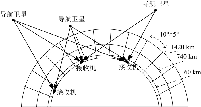
图 2
基于单站双层层析的全球电离层TEC建模示意图
Figure 2.
Sketch of global ionospheric TEC modeling based on single-station two-layer tomography
下载:
全尺寸图片
幻灯片
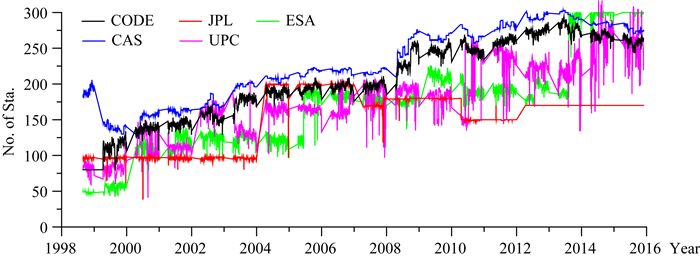
图 3
IGS电离层分析中心1998—2015年每天计算GIM所采用基准站数量对比
Figure 3.
Number comparison of global GNSS stations used in daily GIM computation at IGS-IAAC centers from 1998 to 2015
下载:
全尺寸图片
幻灯片
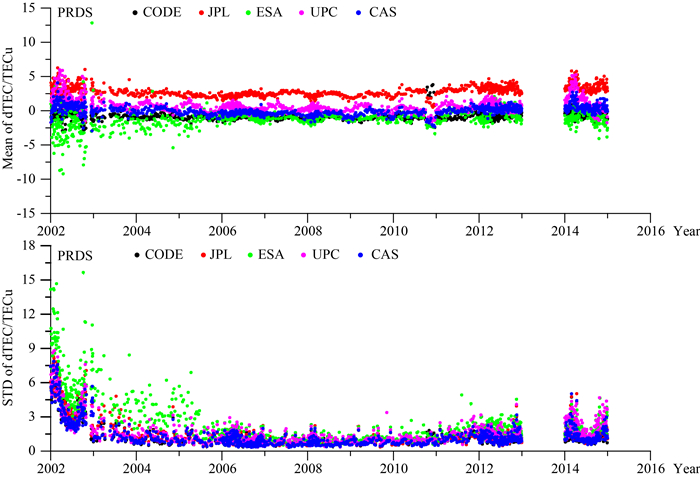
图 4
不同分析中心GIM产品与PRDS基准站(北半球)实测电离层TEC差异统计(上图:均值,下图:标准差)
Figure 4.
Statistics of mean (upper) and standard deviation (lower) of differences between the GIM and the ionospheric observation from PRDS station in northern hemisphere
下载:
全尺寸图片
幻灯片
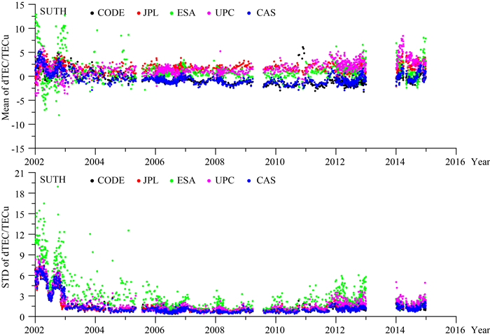
图 5
不同分析中心GIM产品与基于SUTH基准站(南半球)实测电离层TEC差异统计(上图:均值,下图:标准差)
Figure 5.
Statistics of mean (upper) and standard deviation (lower) of differences between the GIM and the ionospheric observation from SUTH station in southern hemisphere
下载:
全尺寸图片
幻灯片
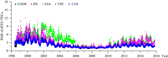
图 6
不同分析中心GIM相对于IGS最终产品的精度时间序列统计
Figure 6.
Statistics of accuracies of GIM from different IGS IAACs with respect to the IGS final GIM product during 1998—2015
下载:
全尺寸图片
幻灯片
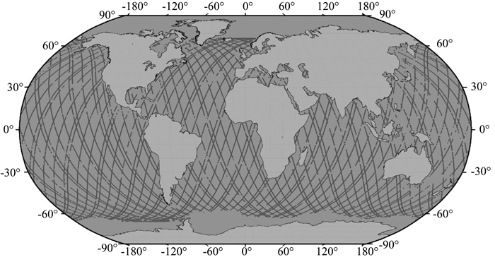
图 7
TOPEX测高卫星2002年1月11—13日在有电离层观测时的星下点轨迹图
Figure 7.
Trajectory of TOPEX sub-satellite point while the ionospheric observation is available during the period of January 11—13, 2002
下载:
全尺寸图片
幻灯片
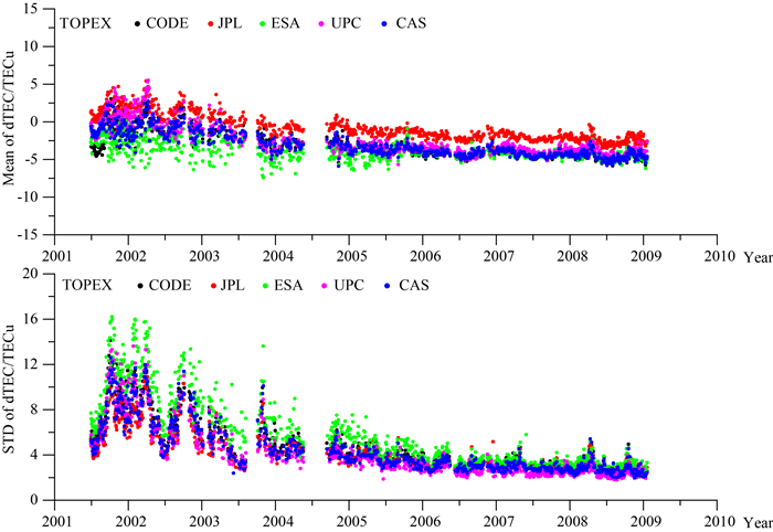
图 8
基于TOPEX测高卫星电离层TEC的GIM精度评估结果(上图:均值,下图:标准差)
Figure 8.
Mean (upper) and standard deviation (lower) of the differences between the ionospheric TEC from TOPEX altimetry satellite and individual IAAC GIM
下载:
全尺寸图片
幻灯片
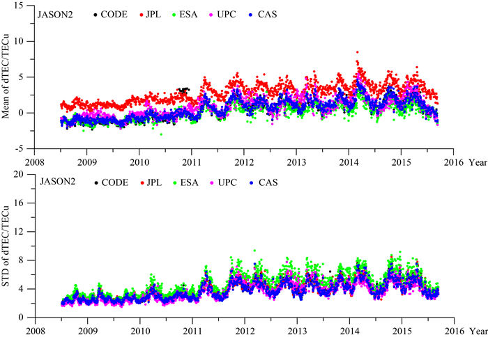
图 9
基于JASON2测高卫星电离层TEC的GIM精度评估结果(上图:均值,下图:标准差)
Figure 9.
Mean (upper) and standard deviation (lower) of the differences between the ionospheric TEC from JASON2 altimetry satellite and individual IAAC GIM
下载:
全尺寸图片
幻灯片
表 1
基于全球分布GPS基准站的不同分析中心GIM内符合精度统计(单位:TECu)
Table 1.
Average precisions of GIM from different IGS-IAACs validated by the ionospheric observation from global GPS stations (unit: TECu)
时间 产品 CODE CAS JPL UPC ESA 2002—2004 (0.66, 3.82) (0.68, 3.79) (3.49, 3.97) (1.57, 4.67) (-1.28, 7.06) 2005—2007 (-0.32, 1.44) (-0.47, 1.42) (2.46, 1.48) (-0.10, 1.77) (-0.17, 2.42) 2008—2010 (-0.36, 1.37) (-0.72, 1.31) (2.21, 1.35) (0.02, 1.68) (-0.39, 1.96) 2011—2014 (-0.03, 2.01) (0.26, 2.08) (3.14, 2.20) (0.60, 2.88) (0.30, 3.23) 平均 (0.02, 2.41) (0.05, 2.33) (2.92, 2.53) (0.58, 3.08) (-0.31, 4.24) 注:2011—2014不包括2013年数据;(A, B)中A和B分别表示均值和标准差.
下载: 导出CSV
表 2
不同分析中心GIM相对于IGS最终产品均方根误差统计(单位:TECu)
Table 2.
Yearly accuracies of GIM from different IGS IAACs with respect to the IGS final GIM product (unit: TECu)
年份 产品 CODE CAS JPL UPC ESA 1998 3.01 3.02 4.27 4.62 4.49 1999 3.64 3.54 4.64 5.64 5.79 2000 4.41 3.91 4.91 6.45 6.94 2001 3.87 3.47 4.34 5.21 6.81 2002 3.26 3.07 3.78 4.27 7.50 2003 2.23 2.21 2.71 2.56 5.57 2004 1.68 1.78 2.45 2.01 4.42 2005 1.49 1.59 2.17 1.68 3.57 2006 1.20 1.25 2.00 1.47 1.67 2007 1.08 1.18 1.92 1.32 1.52 2008 1.10 1.15 1.79 1.28 1.43 2009 1.23 1.22 1.82 1.40 1.45 2010 1.66 1.60 1.94 1.79 2.19 2011 1.88 1.76 2.45 2.44 2.92 2012 2.18 2.05 2.89 2.85 3.44 2013 2.09 2.00 2.73 3.20 3.38 2014 2.19 2.04 2.80 3.77 3.63 2015 1.89 1.86 2.10 3.24 3.71 平均 2.43 2.31 3.05 3.44 4.35
下载: 导出CSV
表 3
基于测高卫星电离层TEC的GIM精度评估统计(单位:TECu)
Table 3.
Accuracies of individual IAAC GIM evaluated by the ionospheric TEC from altimetry satellites (Unit: TECu)
测高卫星 产品 CODE CAS JPL UPC ESA TOPEX (-3.14, 5.27) (-3.06, 4.98) (-0.78, 4.65) (-2.56, 4.95) (-3.84, 6.76) JASON1 (-1.22, 4.18) (-1.27, 3.96) (0.95, 3.87) (-0.88, 3.81) (-1.80, 5.39) JASON2 (0.51, 4.12) (0.58, 3.93) (2.80, 4.18) (0.82, 3.86) (0.18, 5.03) 平均 (-1.10, 4.43) (-1.08, 4.21) (1.15, 4.16) (-0.71, 4.11) (-1.63, 5.63) 注:(A, B)中A和B分别表示均值和标准差.
下载: 导出CSV
表 4
GIM与不同测高卫星电离层TEC之间的系统性偏差统计(单位:TECu)
Table 4.
Systemic bias of the ionospheric TEC from altimetry satellites with respect to that from individual IAAC GIM (unit: TECu)
测高卫星 产品 CODE CAS JPL UPC ESA 平均 TOPEX-JASON1 -1.92 -1.83 -1.73 -1.68 -2.04 -1.84 JASON1-JASON2 -1.73 -1.81 -1.85 -1.7 -0.17 -1.45 TOPEX-JASON2 -3.65 -3.64 -3.58 -3.38 -2.21 -3.29
下载: 导出CSV
-
BD-SIS-ICD. 2012. BeiDou Navigation Satellite System Signal in Space Interface Control Document open service signal B1I (Version 1.0). China Satellite Navigation Office.
Davies K. 1990. Ionospheric Radio. London:Peter Peregrinus Ltd.
Feltens J. 2003. The International GPS Service (IGS) Ionosphere Working Group. Advances in Space Research, 31(3):635-644. doi: 10.1016/S0273-1177(03)00029-2
Feltens J, Dow J M. 2006. Realized and planned improvements in ESA/ESOC ionosphere modeling.//Proceedings of the 2006 IGS Workshop. Darmstadt:ESOC.
Feltens J, Schaer S. 1998. IGS product for the ionosphere.//Proceedings of the IGS Analysis Centers Workshop. Germany:Darmstadt, 225-232.
Fu L L, Christensen E J, Yamarone C A Jr, et al. 1994. TOPEX/POSEIDON mission overview. Journal of Geophysical Research:Oceans, 99(C12):24369-24381. doi: 10.1029/94JC01761
Georgiadiou Y. 1994. Modeling the Ionosphere for an Active Control Network of GPS Stations. LGR-Series-Publications of the Delft Geodetic Computing Centre.
GLONASS-ICD. 2008. GLONASS Interface Control Document, Version 5.1. Moscow:Coordination Scientific Information Center.
Hernández-Pajares M, Juan J M, Sanz J, et al. 1998. Global observation of the ionospheric electronic response to solar events using ground and LEO GPS data. Journal of Geophysical Research:Space Physics, 103(A9):20789-20796. doi: 10.1029/98JA01272
Hernández-Pajares M, Juan J M, Sanz J. 1999. New approaches in global ionospheric determination using ground GPS data. Journal of Atmospheric and Solar-Terrestrial Physics, 61(16):1237-1247. doi: 10.1016/S1364-6826(99)00054-1
Hernández-Pajares M, Juan J M, Sanz J, et al. 2009. The IGS VTEC maps:a reliable source of ionospheric information since 1998. Journal of Geodesy, 83(3-4):263-275. doi: 10.1007/s00190-008-0266-1
Hernández-Pajares M. 2004. IGS ionosphere WG status report:performance of IGS Ionosphere TEC Maps (Position paper). Switzerland:IGS.
Hernandez-Pajares M, Roma Dollase D, Krankowski A, et al. 2016. Comparing Performances of Seven Different Global VTEC Ionospheric Models in the IGS Context. Sydney:International GNSS Service (IGS).
IGMAS. 2016. http://124.205.50.178/product/treepage/tree/nav_id/36/cate_id/37.html.
Jee G, Lee H B, Kim Y H, et al. 2010. Assessment of GPS global ionosphere maps (GIM) by comparison between CODE GIM and TOPEX/Jason TEC Data:ionospheric perspective. Journal of Geophysical Research:Space Physics, 115(A10):A10319, doi: 10.1029/2010JA015432.
Jee G, Schunk R W, Scherliess L. 2004. Analysis of TEC data from the TOPEX/Poseidon mission. Journal of Geophysical Research:Space Physics, 109(A1):A1301, doi: 10.1029/2003JA010058.
Komjathy A, Wilson B D, Runge T F, et al. 2002. A new ionospheric model for wide area differential GPS:the multiple shell approach.//Proceedings of ION NTM 2002, Institute of Navigation. San Diego, CA:NTM, 460-466.
https://www.researchgate.net/publication/265629823_A_New_Ionospheric_Model_for_Wide_Area_Differential_GPS_The_Multiple_Shell_Approach Komjathy A, Sparks L, Wilson B D, et al. 2005. Automated daily processing of more than 1000 ground-based GPS receivers for studying intense ionospheric storms. Radio Science, 40(6):S6006. http://ieeexplore.ieee.org/document/7770163/
Li Z. 2012. Study on the mitigation of ionospheric delay and the monitoring of global ionospheric TEC based on GNSS/Compass[Ph. D. thesis] (in Chinese). Wuhan:Institute of Geodesy and Geophysics, Chinese Academy of Sciences.
Li Z S, Yuan Y B, Wang N B, et al. 2014. SHPTS:Towards a new method for generating precise global ionospheric TEC map based on spherical harmonic and generalized trigonometric series functions. Journal of Geodesy, 89(4):331-345. http://or.nsfc.gov.cn/handle/00001903-5/264665
Liu L B, Wan W X. 2014. A brief overview on the issue on space physics and space weather. Chinese Journal of Geophysics (in Chinese), 57(11):3493-3501, doi: 10.6038/cjg20141101.
Mannucci A J, Wilson B D, Edwards C D. 1993. A new method for monitoring the earth's ionospheric total electron content using the GPS global network.//Proceedings of the ION GPS-93.
Mannucci A J, Wilson B D, Yuan D N, et al. 1998. A global mapping technique for GPS-derived ionospheric total electron content measurements. Radio Science, 33(3):565-582. doi: 10.1029/97RS02707
Mannucci A J, Iijima B A, Lindqwister U J, et al. 1999. GPS and ionosphere.//Stone W R ed. Review of Radio Science 1996-1999. New York:Oxford University Press.
Orús R. 2005. Contributions on the improvement, assessment and application of the global ionospheric VTEC maps computed with GPS data[Ph. D. thesis]. Barcelona, Spain:Universitat Politecnica de Catalunya.
Orús R, Hernández-Pajares M, Juan J M, et al. 2005. Improvement of global ionospheric VTEC Maps by using kriging interpolation technique. Journal of Atmospheric and Solar-Terrestrial Physics, 67(16):1598-1609. doi: 10.1016/j.jastp.2005.07.017
OS-SIS-ICD. 2010. European GNSS (Galileo) Open Service Signal in Space Interface Control Document, Issue 1.1. European Union.
Schaer S, Werner G. 1998. How to Use IONEX. igscb.jpl.nasa.gov/igscb/data/format/ionex1.pdf.
Schaer S. 1999. Mapping and predicting the earth's ionosphere using the global positioning system[Ph. D. thesis]. Berne, Switzerland:University of Bern.
http://adsabs.harvard.edu/abs/1999GGAS...59.....S Warnant R, Foelsche U, Aquino M, et al. 2010. Mitigation of ionospheric effects on GNSS. Ann. Geophys., 52:373-390. http://www.oalib.com/paper/2575522
Yuan Y B, Ou J K. 2002. Differential areas for differential stations (DADS):a new method of establishing grid ionospheric model. Chinese Science Bulletin, 47(12):1033-1036. doi: 10.1007/BF02907577
Yuan Y B, Ou J K. 2004. A generalized trigonometric series function model for determining ionospheric delay. Progress in Natural Science, 14(11):1010-1014. doi: 10.1080/10020070412331344711
Zhang H P. 2006. Monitoring and correction of the ionospheric delay over China area using the ground-based GPS[Ph. D. thesis] (in Chinese). Shanghai:Shanghai Astronomical Observatory.
Zhang H P, Xu P L, Han W H, et al. 2012. Eliminating negative VTEC in global ionosphere maps using inequality-constrained least squares. Advances in Space Research, 51(6):988-1000. http://www.sciencedirect.com/science/article/pii/S0273117712004152
Wen D B. 2007. GPS-based ionospheric tomographic algorithms and applications[Ph. D. thesis] (in Chinese). Wuhan:Institute of Geodesy and Geophysics, Chinese Academy of Sciences.
Yuan Y B. 2002. Study on theories and methods of correcting ionospheric delay and monitoring ionosphere based on GPS[Ph. D. thesis] (in Chinese). Wuhan:Institute of Geodesy and Geophysics, Chinese Academy of Sciences.
Zhang B C, Ou J K, Yuan Y B, et al. 2011. Calibration of slant total electron content (sTEC) and Satellite-Receiver's differential code biases (DCBs) with uncombined precise point positioning (PPP) technique. Acta Geodatica et Cartographica Sinica (in Chinese), 40(4):447-453. https://link.springer.com/article/10.1007/s00190-006-0093-1
李子申. 2012. GNSS/Compass电离层时延修正及TEC监测理论与方法研究[博士论文]. 武汉: 中国科学院测量与地球物理研究所.
刘立波, 万卫星. 2014.我国空间物理研究进展.地球物理学报, 57(11):3493-3501, doi: 10.6038/cjg20141101. http://www.geophy.cn/CN/abstract/abstract10944.shtml
闻德保. 2007. 基于GPS的电离层层析算法及其应用研究[博士论文]. 武汉: 中国科学院测量与地球物理研究所.
http://d.wanfangdata.com.cn/Thesis/Y1623154 袁运斌. 2002. 基于GPS的电离层监测及延迟改正理论与方法的研究[博士论文]. 武汉: 中国科学院研究生院(测量与地球物理研究所).
http://d.wanfangdata.com.cn/Thesis_Y568495.aspx 张宝成, 欧吉坤, 袁运斌等. 2011.利用非组合精密单点定位技术确定斜向电离层总电子含量和站星差分码偏差.测绘学报, 40(4):447-453. http://www.cnki.com.cn/Article/CJFDTOTAL-CHXB201104010.htm
章红平. 2006. 基于地基GPS的中国区域电离层监测与延迟改正研究[博士论文]. 上海: 中国科学院上海天文台.
http://cdmd.cnki.com.cn/Article/CDMD-80022-2006109504.htm -
图(9)
表(4)
计量
- 文章访问数: 4614
- PDF下载数: 820
- 施引文献: 0